Wild nature of Khakassia. Natural features and resources of the Republic of Khakassia. Churches and cathedrals of Khakassia
One of the subjects of the Russian Federation is the Republic of Khakassia. It is located in the Siberian Federal District and borders on the Kemerovo Region, the Krasnoyarsk Cream and the Republics of Tyva and Altai.
The Republic of Khakassia is famous for its rivers - the Yenisei, Abakan, Tomyu, White and Black Iyus.
Flora of Khakassia

The flora of Khakassia is quite peculiar and unusual. Plants that are familiar to all people, as well as species little studied by man, grow here. Here you can see both steppe and meadow vegetation, as well as high-mountain and taiga regions.
As a rule, the mountain taiga belts are suitable for the growth of dark coniferous and subalpine cedar forests. In such forests, round-leaved birch, wild rosemary, Altai honeysuckle, shrub alder and gray willow are often found. Also growing here: lingonberries, blueberries. And in the herbage there are: hairy sorrel, ortilia, bergenia, Siberian geranium.

Cedar and fir grow in the taiga dark coniferous forests. And the undergrowth is: Dahurian rhododendron, wild rosemary, Altai honeysuckle, spirea, currant, mountain ash and alder.
Mixed valley forests are characterized by the presence of birch, cedar, fir, spruce, willow, larch and aspen. In the undergrowth there are: low birch, Kuril tea, currant, spirea, alder and other plant species.

The alpine belt consists of light cedar forests, alpine meadows and mountain tundra. The soil of these places is suitable for the growth of cedar and fir. The undergrowth is also birch, honeysuckle, alder, juniper.
Of the shrubs here are found: dwarf birch, willow, alder.

The tundra of the Republic of Khakassia can also be classified - shrub, lichen, grassy tundra. A large number of plants grow in them - sedges, white-flowered geraniums, schultia. Sheep fescue, daffodil anemone, dryad and Turchaninov's cross are also found here.

The steppe vegetation of the Republic of Khakassia is also diverse. Here grow greyish panzeria, thyme, cold wormwood, teresken, cochia, snakehead. Also, the steppe territories are famous for their caragans, dwarf small-tufted cereals. Steppe herbage are: fescue, thin-legged, feather grass, bluegrass, sedge, white-tomented speedwell, asters, onions and many other plants.
Fauna of Khakassia

The Republic of Khakassia has sheltered many different types animals.
Of the mammals found here: Djungarian hamsters, hares, voles, long-tailed ground squirrels, moles. Here you can also meet mink with muskrat. The permanent inhabitants of these places are: steppe lemming, narrow-skulled voles, shrews and badgers.
Also the inhabitants of these places are foxes, wolves, brown bears, lynx, wolverine.

The large animals of Khakassia include roe deer, Sayan reindeer, elk, musk deer and deer.
The world of reptiles in Khakassia is quite diverse. Here live: viviparous lizards, common vipers, muzzles and patterned snakes.

The world of birds deserves special attention. Each natural zone of Khakassia has sheltered various species of birds. Here are found: quail, bearded partridge, black-headed coinage, chatterbox. Near the reservoirs you can see the Short-eared Owl, Demoiselle Crane, Mallard, Pintail and Gray Duck.
In the steppe regions there are lapwings, yellow wagtails, soots. Representatives of the steppe world of birds are also red-eared buntings and horned larks.

There are also birds of prey in Khakassia - black kite, hawk and saker falcon.
Their bats are inhabited by pond, water and mustachioed bats, long-eared bats, northern kozhanok and two-colored kozhyan.
The water world of Khakassia is not deprived of the presence of inhabitants. The waters of the steppe territories are rich in chum salmon, trout, peled, bream, Siberian vendace. Also common here: omul, carp, pike perch, top. Aboriginal fish are: perch, pike, crucian carp, roach and lake minnow.
Climate in Khakassia

Spring starts in April and ends in May. During this period, the snow cover melts, and the average air temperature ranges from 4 to 15 degrees Celsius.
Summer comes to Khakassia in June. The air temperature ranges from 18 to 24 degrees, and the absolute maximum is +38 degrees. August is characterized by heavy rainfall.

September and October are the autumn months of Khakassia. The air temperature begins to drop to +10 and below. Night frosts return in October, and snow falls in November.
Winter in Khakassia is quite cold. The coldest mark in January is -52 degrees. As a rule, winters are dry, with strong and persistent frosts. Snow cover is formed already in early November and lasts until early April.
Information, description, photos and other useful information about Khakassia
Khakassia - a place of power, a zone of comfort and attraction
Khakassia has everything what a traveler can wish for: high snow-capped mountains, forests where no human foot has set foot, cool and clean rivers, endless fragrant steppes and a huge number of various reservoirs.
The mountains, whose height reaches 3000 meters, hide a lot of interesting things. The purest rivers, originating in the Sayan Mountains, carry their waters to the largest artery of Khakassia - Abakan river, and then to the very deep river Russia - Yenisei. Water resources Khakassia is complemented by 300 lakes, salty and fresh, the most famous of which are the healing lakes of Shira, Bele and Khankul. But despite the fact that the mountain landscape occupies almost two-thirds of the republic, the true Khakass landscape is a dry, hard, boundless steppe, with barrows scattered throughout its territory. Favorable climate, a rare combination of dry steppe air and a large number fresh and mineral lakes has attracted people since ancient times.

About 30 thousand historical monuments are under the Khakas sky - ancient settlements, mounds, rock paintings, menhirs with runic inscriptions of the ancient Khakas, sanctuaries.

The oldest observatory of Khakassia - Chests

Salbyk barrow

Not far from the capital of Khakassia - is the Valley of the Kings - a place where several cultures passed. The main attraction of the Valley of the Kings is built in the 4th century BC.
Nature of Khakassia

Mountains occupy two thirds of the territory of the republic. Kuznetsk Alatau in the east and Western Sayan in the south. The mountains are covered with dark coniferous taiga, there are sharp peaks and snow-covered loaches. The steppes fill the intermountain space - the Khakass-Minusinsk basin with flat and hilly relief forms. It is in the steppes that traces of ancient civilizations are concentrated.

The climate in Khakassia is sharply continental, it is expressed in a cold snowy winter, in warm spring, in hot and dry summer, long autumn.

Natural barriers - mountains protecting the territory from cold air masses form their own microclimate, which allows growing watermelons, apricots, apples, grapes. Agriculture and animal husbandry is the main activity in Khakassia.


Population of Khakassia

The indigenous inhabitants of the Khakass-Minusinsk basin are the Khakass, a Turkic-speaking people. According to the anthropological type, the Khakass belong to the Mongoloid race with an admixture of Caucasoids.

The Khakases are a peace-loving and hospitable people with a bright original culture based on shamanism and Manichaeism. Today, the indigenous population makes up just over 11% of the total population of the Republic. 85% of the Khakass retained their native language.

Souvenirs of Khakassia


Capital of Khakassia


which offers a magnificent panorama of the Sayano-Shushenskoye reservoir, the region of the Kuznetsk Alatau ridge with a beautiful golden lake valley and smooth passes, and of course the world-famous ERGAKI mountain range,

due to its beauty and accessibility, it has become the Mecca of mountain tourism and rock climbing for the whole of Siberia. The beauty of peaks and gorges, waterfalls and lakes cannot be underestimated, and it is hard to believe that so many wonders of nature are located on the territory of only 50 square meters. km! The main attraction is the profile of the Sleeping Sayan - a mythical hero, as well as the Hanging Stone - a 300-ton colossus, swinging over the abyss.
Rafting, rafting
Floatable rivers flow through the territory of Khakassia and the south of the Krasnoyarsk Territory. Convenient transportation and the beauty of the surrounding nature attract many rafting enthusiasts. For beginners - rafting on the Kazyr river with the passage of the Gulyaevsky threshold.

caves
Caves are another pride of Khakassia. There are more than 160 of them. Especially rich in caves is the karst section of the Shirinsky district, known to speleologists as Syr-from-holes. The most famous are the cult caves of the black devil "Kashkulakskaya" and "Pandora's Box" (about 13 km), and for beginner tourists we would recommend the Borodino and Archaeological caves.
Tour routes
Khakassia is a country of antiquities and contrasts, where nomads' yurts coexist with advanced enterprises. Excursions in Khakassia are not only an acquaintance with ancient history- "Temple of Time" (Chests), ethnicity and culture, but also admiration for the scope of engineering when creating.

There are many excursion programs lasting from 1 to 10 days. Good organization, short journeys, as well as the beauty of sightseeing sites will help you satisfy your curiosity and replenish your collection of impressions!

Task: Protection of nature and respect for it. Goals: 1) Instilling love for nature, for the environment around us. 2) Be able to use the Red Data Book of Khakassia. 3) Expand the horizons, the curiosity of the guys about the nature of Khakassia. 4) Development of the ecological direction (against pollution environment) in relation to all life on Earth.
The Republic of Khakassia The Republic of Khakassia is a constituent entity of the Russian Federation and is part of the Siberian Federal District. In the north, east and southeast Khakassia borders on Krasnoyarsk Territory, in the south - with the Republic of Tyva, in the southwest - with the Republic of Altai, in the west - with the Kemerovo region. Administrative center Abakan Population 570.0 thousand people Area 61.9 thousand km2
Natural conditions Climate The climate is sharply continental, with dry, hot summers and cold winters with little snow. average temperature July air 17°С, January -18°С. Main natural resources The Republic of Khakassia is one of the oldest mining regions in the east of Russia. On its territory, iron, molybdenum, gold, coal, mineral and radon waters, non-metallic minerals are mined: barite, bentonite, facing marbles and granites, building materials. Deposits of copper, polymetals, phosphorites, asbestos, gypsum, jade, jadeite have been explored.
The nature of Khakassia is unique. The Republic of Khakassia compares favorably with the wealth of mineral, forest and water resources. The total area of the forest fund is 61% of the territory of the republic. The main forest-forming species in the Republic of Khakassia are cedar, fir, pine, spruce, larch, birch and aspen. The most valuable are cedar forests (31% of the forest fund). The most valuable species of wild plants grow in the forests. medicinal plants with high demand.
The special value of salt lakes in the republic. There are more than 100 of them in the republic. Currently, 24 reservoirs with a mineralization of more than 10 g/dm3 have been identified on the territory of the republic, which can be used for baths and bathing for medicinal purposes. Recognition of the unique potential of salt lakes, natural healing resources, historical monuments. So, for example, Lake SHIRA is an All-Russian health resort.
Siberian Switzerland. The Republic of Khakassia has unique opportunities for the development of tourism. On its territory, on the spurs of the Eastern Sayan and Kuznetsk Alatau, the water flow of the two largest Russian rivers, the Yenisei and the Ob, with more than 3,000 small and large watercourses, the Krasnoyarsk and Sayan reservoirs, is formed. The taiga massifs with a total area of about 4 million hectares are fraught with innumerable riches of fauna and flora. Here you can admire and get acquainted with various geographical areas, starting from the sultry steppes and ending with the eternal snow-covered ridges with elevation changes up to 200-2500 meters above sea level. Quite deservedly, the Khakassian taiga is called the Siberian Switzerland.
Lakes of Khakassia Khakassia is really known for its lakes - Tus, Bele, Utichye, Itkul, Shira, Khankul, Ulukgol, Shunet and others - and each lake has its own purpose from a medical point of view. Rest on the lakes of Khakassia is quite worthy and healing - with swimming and sunbathing. The lakes of Khakassia are rest and treatment. The following lakes deserve attention: Bele - a double lake, consisting of salt and fresh parts; Tus is the saltiest lake; Lake Utichye - surrounded by mountains on all sides; Shira - you can not only swim in it, but also go to archaeological excavations or in a cave; Ulukgol - it can be considered a kind of ornithological reserve; Khankul - underground sources are located nearby; Lake Shunet with therapeutic mud and others.
125 species of angiosperms, 1 species of gymnosperms, 10 species of ferns, 10 species of mosses, 12 species of lichens and 10 species of mushrooms are placed in the Red Book of Khakassia. For each plant species included in the Red Book, its status is indicated. Species status is a threatened condition category adopted by the International Union for Conservation of Nature (IUCN).
On the territory of Khakassia, there are 128 rare and endangered species of animals listed in the Red Book. Of these, the class of insects includes 21 species, fish - 6 species, amphibians - 3 species, reptiles - 3 species, birds - 79 species and mammals 16 species. For each species of animal included in the Red Book, its own category of rarity status is indicated.
Museum-reserve "Kazanovka". There is a legend about the appearance of this stone. The old woman (Hoarfrost) and the old man (Apsakh) brought their people to the happy valley - they stopped, looked around: they liked the place. We decided to live here, but Frost said that the aal should be placed to the right of Mount Aar Tag, while Apsakh liked the left side more. They argued for a long time - they fought. Ine won. In anger, she pushed the old man so hard that he flew across the river and fell to the top of Mount Aar Tag. From resentment, the old man turned into stone. You can still see it now - a stone rock rises on the top of the mountain (it is called Apsakh tas, Stone Old Man), the silhouette of which surprisingly resembles an offended old man. Hoarfrost was very worried about her husband's insult - she moved a little to the side, sat down ... and also turned into stone. Reserves “Chazy” and “Small Abakan” (the predecessors of the “Khakassky” reserve) are being created on the territory of Khakassia. It was organized in 1994. It was headed by Ph.D. Yu.I. bushes.
Posted Sun, 29/05/2016 - 10:25 by Cap
Khakassia is an interesting and mysterious region located in the Western Sayan Mountains, a little east of Altai. The junction of Altai and Sayan makes this place mysterious and attractive!
Remains of ancient beliefs, practiced shamanism, pathogenic places, mysterious caves in the remote taiga, habitats of spirits - all this and much more can be found in Khakassia.
As for anomalous zones, there are three of them in Khakassia. There is also its own Valley of Death, in which the space-time continuum is bent (time bag). Let's say it's not the most pleasant place. Located in the north of Khakassia. The second place is located 33 kilometers upstream of the Abakan River from our city of Abakan. Quite often, people who spent the night in that valley went crazy or died under strange circumstances.
The third is located in the area of \u200b\u200bLake Fyrkal towards Kommunar to the north, but you can’t get there by car, only on foot. A dead place, even the beast bypasses it. Ufologists say that it is part of one of the twelve anomalous triangles on the planet, such as the Bermuda Triangle.
.jpg)
"Chests" in Khakassia
Imagine a valley with a diameter of 12-15 km, surrounded by mountains. Practically in the center of this valley there are stone pyramids - the people call them "Chests" for the unusually regular shape of the peaks in the form of squares.
The length of these pyramids is about 300 m, the height is 60-70 m. They are, in general, a complete copy of the Aztec and Mayan pyramids. When I first saw them, I was just shocked,
I didn't believe my eyes. By profession, I am a historian, an archaeologist, and to see this at my side is something unimaginable. There are three villages next to these pyramids.
At first, naturally, I began to ask local residents about these constructions. Fortunately, one of my classmates lived in such a village, and through him I managed to get acquainted with many. Everyone kept repeating in one voice - the place is dark, spirits constantly “fly” there, in no case should one meddle there. To my desire to spend the night on the top of the most preserved of all the pyramids (and there are about 12 of them), the reaction is like a plague patient. They twist a finger at the temple and try to quickly wash off.
Finally, with two comrades, I stayed at the Chest. The night passed relatively calmly, except for all sorts of mystical things, such as - exactly at twelve o'clock the constantly blowing wind ended and an extraordinary silence ensued. It was heard how in a distant village, ten kilometers away, cow bells sounded. Then suddenly a small hollow was filled with thick fog. And then, in the complete absence of any movement of the wind, I suddenly heard the rustle of branches and the rustle of foliage (larch grew in the hollow). This, sorry, could not be. However, we digress from the topic.
So. The wind blew again at exactly 3 o'clock in the morning. (In the future, I checked, spending the night several times, all miracles are exactly on schedule!). A few hours later the sun began to rise, and since it was a full moon, I looked to the west, the moon was setting there - but what happened to her! The dark red disk began to rotate unbelievably around its axis, changing its shape, tending more and more to an ellipse. Moreover, all these metamorphoses took place in a matter of not only minutes, seconds! Until the sun rose almost completely, my friend and I (the second one slept in a tent) stared at the bloody disk, unable to tear ourselves away.
A lot of time has passed (it was 1991), but still, although not so clearly, I remember this disk of the Moon, morphing according to my whim. He did not promise anything good.
When we arrived at the village and had a good sleep, I began to ask the locals, and found out that all kinds of UFOs of all sizes, from balls to plates, and all kinds of colors, were roaming the valley of the “Chests”. When their accuracy is especially high, no one knew, they simply noted the days of their appearance. By the way, I was told that near one of the "Chests", back in Soviet times, a stone was dug up (they plowed the field and opened the shaman's grave with a tractor), which depicted the constellations of the other hemisphere, and some stars, visible almost through a telescope .
To be honest, I didn’t manage to verify this information, some say that everything they found was taken to some St. Petersburg institute, others don’t really remember anything at all, so I can’t confirm it, let alone refute it. Ho! The world-famous scientist, professor, writer, archaeologist Vitaly Epifanovich Larychev has been going to this valley for more than 20 years to dig. He even has a book on Chests. I was very interested in this strange connection between "Chests" and UFO. In general, there are many legends and true stories about this valley. It is reliably known that a mighty people lived in it for a long time, because they built stone houses, fortresses, skillfully used natural structures. And when the Mongols in the 12th century passed here - they slaughtered the entire population and tried to destroy all the buildings! Such a birth for them was not carried out. To everyone and everything!!! Now NOBODY knows what was there and who lived there!!!
For example, I strongly suspect that there existed a completely non-simple people professing their completely non-shamanistic religion. There is a suspicion that there are hollow places in the littered tops of the chests and there something is waiting for its time. By the way, I forgot to say. If scientists cannot give an exact date, how long ago people lived in the valley, that they approximately name the time of existence of the pyramids - 35-40,000 years ago they arose, and since then they have remained almost unchanged!
It is located in the Kuznetsk Alatau (Khakassia), four kilometers from the village of Malaya Syya, on the left bank of the Bely Iyus River. The length of the cave passages is about 11,000 meters and the depth is 195 meters.
The cave was discovered in the 1970s. The name of the cave was proposed by a Novosibirsk biologist and chosen by lot from a number of other names.
The cave has numerous wells, large halls, galleries at several levels, cave lakes, sinter formations.
One of the most dangerous caves in Russia.
There have been three fatal accidents in Pandora's Box Cave since its discovery to date.

PANDORA'S BOX. GENERAL INFORMATION.
Pandora's Box is a cave on the left bank of the Bely Iyus River, in the Kuznetsk Alatau, Republic (Khakassia).
The length of the mapped passages of the cave is about 11 km, the depth is more than 180 m. Currently, at the initiative of Krasnoyarsk speleologists, work is underway on a new topographical survey of the cave, including previously unfilmed passages. The labyrinth-type cave, in limestone, has one entrance.
There are numerous wells, large halls, galleries on several levels, cave lakes, sinter formations. The average temperature is +5 °С.
There are bats.
The cave was discovered in the early 1970s by employees of the Syi glaciological station. At that time, the cave was the only entrance light grotto Shiroky. Since 1976, speleologists Osinnikov led by V. Vlasenko have been trying to penetrate the underground system through neighboring small caves.
In 1981, targeted excavations in Shirokoye by speleologists from Osinnikov and Tomsk uncovered a passage to the upper floors of the cave. In the future, speleologists of Novokuznetsk were also engaged in the study of the cave. The name of the cave was proposed by the Novosibirsk biologist N.P. Mironycheva-Tokareva, and chosen by lot from a number of other options.
Incidents in the cave
Three people died in Pandora's Box.
12/03/1989 Andrey Ageev from Novosibirsk crashed to death.
In the summer of 2003, Novosibirsk archaeologist Stanislav Shubin died in the upper part of the cave.
On February 2, 2005, while trying to dig a passage at the bottom of the cave, the Novosibirsk speleologist Pavel Galkin died under the rubble.
There are also reports of missing tourists in the cave.
took place in the cave anomalous phenomena.
Pandora's Box, Emerald Lake 

Statue of Khurtuyakh-Tas
Khurtuyakh-Tas is translated as "Stone Old Woman". People believe that she helps and fulfills desires. Childless women go to her to beg for children, men ask for the fertility of the land, cattle. They bring her gifts and leave them at the foot. It is located in the steppe of the Askiz region.
.jpg)
seismic zone
Anomalous zones with high energy are common. Old mounds with lying stone slabs are popular with residents. You stand on the stove, raise your hands up - and you are in a stream of power. Yesterday, February 10, 170 km south of Abakan, another earthquake of 6 points occurred in the Tashtyp region. Even 20 years ago, such phenomena were not heard in these places. Maybe seismic activity started in response to our visits?
"Askiz Poltergeist",
involuntary miracles in the village of Askiz, from which three people died. A book has been written on the research material, which is being printed now, to the amount of 5000 copies. in the publishing house "Nauka". There is a huge video material - three cassettes of three hours each. Location filming, eyewitness memories and stories, special filming using scientifically developed techniques.
Studies of the "Mercury Man".
Krasnoyarets Zhigachev /I don't remember his name/, visited a flying saucer. After that, mercury began to synthesize in his body! At first it was just bumps on his legs, the doctors prescribed heating for him, the bumps increased, they cut him up and the doctor was horrified, mercury poured out of the cuts! He was urgently sent to Krasnoyarsk. I will not retell much. I am under the impression of video recordings / also about nine hours of video / - professors and academicians in the hospital open his tumors - and mercury pours out of them on the operating table! I CAN'T IMAGINE THIS! Academicians and professors shrug their hands in front of the camera. Eggo's body really synthesizes mercury! Clots of mercury were found in the muscles, skin of the legs, in the scrotum, in the lungs. During a special scan at the clinic, mercury was found in the bones of the legs!!! All of this is filmed!!! EVERYTHING is seriously documented!!!

Suicidal zone
Last week in Khakassia five people committed suicide within two days. In this regard, one Indian film comes to mind. The plot is this. The guy and the girl love each other, but the girl's evil father does not allow them to get married, and the young, instead of sending him to hell, decide to jump into the abyss together. When she falls, the girl breaks to death, and the guy clings to a snag with his shirt, from which he cannot unhook himself, and thus remains alive.
Here, in Russia, you can get off with a week in a mental hospital for a failed suicide, but in India (as in some other countries) you can get a real term for this. In general, the guy gets a year in prison. When he leaves, he finds another girl, marries her. But the evil father of his first lover sets up a car accident for the newlyweds, as a result of which both die.
A few years ago, one of the Abakan psychiatrists told me in an interview that in some regions of Khakassia there is some kind of anomalous "suicidal" zone. It was then about the Tashtyp district. For some inexplicable reason, this area had the highest suicide rate in the region. Today, perhaps, such zones have "moved" to other territories.
Just like a couple of years ago, today, people who decide to commit suicide mostly hang themselves and shoot themselves. Shoot more often hunting weapon. The free circulation of combat, as you know, has been prohibited in our country since the time of Lenin (although in the former socialist camp of Eastern Europe, as well as in the Baltic states, this ban has long been lifted). It's probably right. We are not the people to buy military weapon and lock it with seven locks. In the hands of our man, it will definitely shoot, and if not at others, then at itself. Any person on our streets will say that in Russia, the removal of the ban on the free possession of military weapons will only increase the number of murders and suicides. And this is not at all good for our government. Is it in vain, for the sake of improving the demographic situation, that we invented the so-called “maternity capital”?

Stone old woman INEY-TAS
Location: the picturesque rock Inei-tas (Stone Old Woman) is located one kilometer northeast of the village of Kazanovka, in the Askizsky district of the Republic of Khakassia, on the left bank of the Askiz River
Inei-tas patronized cattle breeding from ancient times and until the 50s of the last century she “helped” people. At Inei-tas, tag taig were performed - rituals of sacrifice to the mountain spirit, the patron of the clan, and asked for help in various matters. At the very foot of Inei-tas, a platform was cleared and sprinkled with river sand, on which 14 sculptures of domestic animals were installed. Bulls, horses, sheep were made of river pebbles and red sandstone. Only three figurines from this collection have survived. And Inei tas itself was blown up at the very beginning of the 60s of the last century.
During the war and in the post-war years, people again began to come to Inei tas and perform rituals here. The then ideologists did not come up with anything better than how to destroy the cult monument. The amazing open-air temple was destroyed. They say that after that, cattle in Khakassia began to breed worse. They also say that none of the participants in this sacrilege ended their lives safely. And Inei-tas enjoys special reverence even after “death”.
Now the mountain where the stone stood is called Hoarfrost (foot Hoarfrost). Rites are again held here, those passing by will certainly do “sec-sec”, on the branches of birch trees, the grove of which surrounded the place where the Stone Old Woman used to stand, they tie a chalama. Those who have been here can fully feel the beauty and strength of this unusual place, where grandmother Iney, even having lost her former appearance, again helps her people.
How to get there: from Abakan to Askiz village (92 km.). Further to the village of Kazanovka about 30 km
Geographic coordinates: 53.22589 90.071927
Address:
Askizsky district, with. Kazanovka

Grotto TWO-EYED
Grotto Two-Eyes
Location: the grotto is located 50 km west of Abakan in the Bogradsky district of the Republic of Khakassia, on the river. Tolcheya, 1.5 km west of the village of the same name
Dvuglazka (Grotto "Dvuglazka", "Glyadeny") is a multilayer natural monument of the Stone Age in Khakassia. This name is due to the fact that in its vaulted ceiling there are two light holes of natural origin - two "eyes".
This is the earliest known site of ancient people in the Minusinsk Basin (100 - 35 thousand years ago), explored by Z. A. Abramova in the 1970s. The entrance to the grotto is located at a height of about 50 m from the water's edge. The grotto is very comfortable for habitation. It is roomy (15 m deep and 7-10 m wide), oriented to the south and well warmed up by the sun.
The excavations revealed several cultural layers, the lower of which belong to the Mousterian era. This is the time of the Ris-Wurm interglacial (100 - 80 thousand years ago) and the Würm glaciation (80 - 12 thousand years ago). Geologists believe that then the climate was relatively warm and dry. Steppe vegetation prevailed near the grotto. Dark coniferous forests grew in the Yenisei valley: spruce, cedar. There were many birches. Stone tools and many animal bones were found in the grotto ( food waste), the bones belonged to the kulan, horse, rhinoceros, bison, argali, saiga, reindeer. From predators - bones of a hyena, a lion, a bear, a wolf, a fox. From 40 thousand years ago, the layers belonged to the late Paleolithic, and from 12 thousand years ago (upper 2 layers, 50 cm) to the Mesolithic.
How to get there: along the M-54 highway from Abakan to the village of Red Stone (about 47.5 km). Further to the village of Borodino 10 km. Grotto "Dvuglazka" is located 2.5 km from the village of Borodino and 1.5 km from the village of Tolcheya
Geographic coordinates: 54.084856 91.064752
Address:
Bogradsky district, village Tolcheya

Mount CHALPAN
Location: the mountain is located on the territory of the State nature reserve"Khakassky", on the site "Lake Bele" in the Shirinsky district of the Republic of Khakassia.
The height of the mountain is 586.3 above sea level. Mount Chalpan is a mountain rise on the northwestern shore of Lake Bele. Stony steppes with outcrops of rocks are widespread on the southern steep slope, and various variants of steppe phytocenoses are found on gentle slopes. A birch-larch copse stretches along the coastline. On the southern slope of Mount Chalpan there is a unique petroglyph, which is a graphic chronicle of history. Archaeologists have established that some of the rock carvings of Mount Chalpan date back to the second millennium BC.
Mount Chalpan has environmental, scientific, aesthetic, educational, aesthetic, recreational value. Here, in the old days, the Khakass mined whetstones for the point of knives. At the top of Mount Chalpan is an ancient fortress.
How to get there: from Abakan along the M-54 highway to the village of Znamenka 80 km, then turn left and drive 55 km to the village of Borets. Then about 32 km to the village of Shira. Lake Bele is located about 25 km from the village of Shira.
Geographic coordinates: 54.703889 90.154167
Address:
Shirinsky district, lake Bele
.jpg)
Ancient Temple Complex ZENHYR
Location: The ancient temple complex Zenkhir (Uzynkhyr) is located in the Ust-Abakan region of Khakassia, near the village of Prigorsk
Translated from Khakass, Uzynkhir means "long ridge". The city with all its buildings practically disappeared into the ground. Only thick, at least 2.5-3 m, stone walls of the temple are clearly visible, which is 15-20 m from the settlement itself. The material for construction, obviously, was delivered from ancient quarries and the rocky coast of the Yenisei. According to scientists, Zenkhir was built by the Afanasyevites. Until now, it was believed that they did not build cities, but lived in small villages and settlements scattered along the banks of the rivers. However, Zenhir refutes this view.
How to get there: from Abakan to the village of Prigorsk about 30 km. Temple complex Zenkhir is located about 3 km from the village of Prigorsk
Geographic coordinates: 53.931111 91.286389
Address:
Ust - Abakansky district, Prigorsk settlement

Mount KUN TAG (KUNYA)
Mount Kunya
Location: left bank of the Krasnoyarsk reservoir, not far from the village of Ust-Abakan, Ust-Abakansky district of Khakassia
The ancient mountain Kyun Tag or Kunya, translated from Khakass means "Mountain of the Sun" and is a cult and sacred mountain for the Khakass, to worship the deity of the Sun. The height of the mountain is over 400 meters. At the top of Mount Kunya there is an ancient fortress, from where a stunning view of the Yenisei valley opens.
Even in the Bronze Age, more than 4,000 years ago, people used this mountain to hide from an enemy raid. It stretched along the ridge separating the gentle slopes of the mountain from its inner part, where not only women and children, but also livestock could hide in the decay. And male warriors could successfully defend the wall from enemies. It was unrealistic for the enemy to get inside the fortress along the steep slopes - even weak women and children could easily throw the attackers down, bringing down flagstone fragments on their heads. There is a lot of flagstone in these places, which made it possible to fold the wall without much labor. The ancient fortress has been used for thousands of years.
Mount Kunya is a grand monument of rock art. A small, only a few tens of meters in length, section of the wall cuts off the cape with a flat ritual platform. On the rocky cliffs of this cape is the famous Podkuninskaya petroglyph. There are 323 figures depicted on the ancient drawings of the inscription: people, deer, goats, horses, camels, birds, bears. The drawings are dated to the 2nd millennium BC.
How to get there: from Abakan to the village of Prigorsk about 30 km. Then 12 km to the village of Mokhova. Mount Kunya is 3 km along dirt road from the village of Mokhova
Geographic coordinates: 53.889803 91.418744
Address:
Ust-Abakansky district, town. Ust - Abakan, aal Mokhov

Tuim ring
Tuim ring
Location: the ancient monument is located on the 8th km of the Shira-Tuim road, in the Shrin district of the Republic of Khakassia
Tuim-ring is a funerary-cult monument of the Okunev culture. It is one of the most interesting objects in Khakassia. On a flat area between the road and the rock, a large square is laid out of stones, the diagonals of the square are also lined with stones. A cromlech (circle of dug menhirs) with a diameter of more than 80 m was built around the square.
In the center of the monument are the slab graves of a female priestess and two children. There are 4 large stones around the circumference, marking the four cardinal points. From the female burial to the east, a symbolic path was laid out, bordered by several small stones. In its own way, the monument is unique and is comparable in value to the English Stonehenge, although it is inferior to it in size.
There is an opinion that the Tuim-ring was not only a cult place, but was also used as an ancient observatory - the stones at the corners of the Tuim-ring are oriented to the cardinal points.
Unfortunately, during the construction of the road, the old cromlech was destroyed, and now you can only see its modern restored version. But the spirit and energy of the old place remained.
How to get there: from Abakan along the M-54 highway to the village of Znamenka 80 km, then turn left and drive 55 km to the village of Borets. Then about 32 km to the village of Shira. From the village of Shira to the village of Tuim, the distance is 18 km. The ancient monument "Tuim ring" is located on the 8th km of the road Shira village - Tuim village
Geographic coordinates: 54.393869 89.948518
Address:
Shirinsky district

Gravity Anomaly
The road Abakan - Sorsk, not far from the turn to Lake Ulukh-gol, in a place called Kuten-Buluk - a gravitational anomaly - the cars themselves go uphill, and the water runs uphill.
Possibly large deposits of ores.
Julia mine
Bogradsky district Rudnik Julia. True, it cannot be called a uranium mine. because uranium was not specifically mined there, but there are uranium deposits there ....
but for 30-40 years it has not been working and the village is abandoned. UFOs have been observed.
Anomalous zones in the taiga
In the taiga regions of Khakassia, small areas of terrain with ugly trees are often observed, lightning often strikes these places, sometimes fireballs are observed. Mechanical watches in such places are in a hurry or behind, by 2-3 minutes per day. While in such a place, a person feels some kind of uncertainty, fear. The zone is usually clearly delineated, outside the zone everything is fine. Such zones are well identified by dowsing, the frame deviation angle reaches 180 degrees.
MYSTERIOUS FOREST
Nature is fragrant with juicy greenery of herbs and the aroma of flowers, the quiet whisper of leaves under a gentle breeze and the singing of birds creates a unique peace and comfort in the soul. In the shade under the cool, spreading crown, they ate a good rest lying on the grass, where life is also in full swing, hard workers ants scurry about, somewhere a beetle is busily crawling, somewhere a grasshopper chirps, but a chipmunk with swollen cheeks or a squirrel in the branches of a pine slithered - such an understandable and the usual life of the taiga.
I slowly climb the slope to the hill and suddenly before my eyes an unusual picture that breaks the taiga harmony: not far away is a large dark spot of a dead forest, the greenery of the grass suddenly breaks off, under my feet there is a thin layer of gray dryish moss, the mighty trunks of ugly trees are completely bare, without bark, branches of a bizarre shape, sometimes they are almost twisted into a spiral, sometimes they are spread out in some completely unnatural way and not a single leaflet, even the wind does not shake them, as if in some long-forgotten old fairy tale about Baba Yaga. Windbreak, there are no old rotten trees either, a flat place overgrown with moss.
And the further I go deeper into this dead realm, the more anxious it becomes in my soul, some kind of unaccountable anxiety, a feeling of uncertainty, grows. Birds are not seen and not heard, even mosquitoes, these eternal companions of the taiga have disappeared somewhere and are no longer ringing in their ears, and there are no signs of life on the ground in the moss either, only huge curved roots under the trees stick out of the ground, as if they are also going to run somewhere . Involuntarily I quicken my pace and in ten minutes I go out to the edge of this dead place.
Curiously, the border of the dead zone is clearly marked by dense green thickets, which are filled with ordinary taiga life. I don’t know how this mysterious forest arose, what and when it killed it, but the uncertainty passes, and curiosity takes its toll, I go back to look at everything more carefully, at the same time I cut down a few flakes from trees, the tree is clean, there are no traces of pests, the soil is ordinary loamy, only humus almost none, and how could he get in a dead forest. It will be necessary to visit here in winter, to see the traces of animals, do they also bypass it. I heard many different legends about such places, but I saw it for the first time.
Anomalous area on the road
Again in Khakassia, an accident occurred on the Yenisei highway. 405 km of the road became fatal for a resident of the village of Ust-Abakan, who, while driving a Honda Accord, lost control, hit a metal fence and allowed the exit to a ditch. According to the UGIBDD of the Ministry of Internal Affairs for the Republic of Kharkiv, as a result of an accident, the driver received a head injury, multiple bruises and abrasions of the body, and was hospitalized.

SACRED PLACES OF KHAKASIA
At the XII Congress of the Khakass people held on March 18, its participants approved a list of sacred places in Khakassia. The director of the Khakass Research Institute of Language, Literature and History, Doctor of Historical Sciences Valentina Tuguzhekova, told the Abakan correspondent about the purpose of this list and what objects were included in it.
The need to create a list of sacred places is caused by socio-economic changes recent years. Today, private individuals can rent vast territories (taiga, fields, etc.) on which objects sacred to the Khakass people can be located. And it is necessary to do everything possible so that these sacred places remain accessible for ritual practice. At the congress, we approved a list of 96 sacred places of the Khakass people, then we will submit it to the Supreme Council of the Republic. We hope that in the future, within the framework of the law on historical and cultural heritage, the sacred places of the Khakass people will be taken under state protection.
What is considered a sacred place?
A list of sacred places has been approved in Khakassia. The meaning of the word "sacred" (from the Latin "sacer" - sacred) is cult, ritual, secret. Sacred monuments of Khakassia are part of the ethnic culture of the Khakass.
Sacred, sacred place - a place that has a sacred status; feature selected from area Everyday life and designed to perform regular cult activities aimed at interacting with sacred entities and forces. It differs from worldly and religious spatial objects by a combination of ideal (spiritual) and material (physical) characteristics. Ideally, in religious consciousness, a sacred place is a value of a high order, the earthly residence of spirits and gods, the concentration of magical powers that evokes a feeling of reverence and requires an extraordinary respectful attitude. The presence of such characteristics in historical documents or ethnographic data makes it possible to identify a spatial object as a sanctuary, a sacred place.
A concrete study of ancient sanctuaries shows that in most cases the places for their arrangement were not chosen at all arbitrarily. Man singled out places in the surrounding earthly world that evoke strong emotional reactions, awaken the imagination and stimulate intellectual activity; these loci of space corresponded to religious ideas about the habitats of spirits, gods and other "forces", marked by the quality of holiness.
In the early stages of history, objects of the natural landscape (mountains, water sources, etc.) were marked strictly according to their genera. As a result, "tribal territories" were formed, which had pronounced natural boundaries. During the development of the territory, the most important was the landscape object (valley, mountain, lake, etc.), that is, the place where people gathered for public events. This is how the ancestral places of worship took shape.
Among the peoples of Southern Siberia, natural places where national holidays, religious rites, and shamanic rituals were held were considered sacral, that is, sacred places. As a rule, sacred places are associated with the traditional worldview of the indigenous peoples of Southern Siberia. As before, most of the indigenous peoples of Southern Siberia (Khakas, Tuvans, Altaians, Shors) deify nature, natural elements, worship of various natural elements, spirits is preserved in folk memory and ritual practice: the spirit of fire, the spirit of water, the spirit of mountains, etc. d.
What is included in the list
In Khakassia, as in other regions of Southern Siberia, sacred places include not only sacred mountains, certain areas, but also archaeological sites: ancient mounds, stone statues, etc. According to the ethnographer Viktor Butanaev, there are about 200 places of worship in Khakassia According to the Council of Elders of the Republic of Khakassia, there are more than 300 of them.
The most revered sacred mountains among the Khakass population are: Borus, Izykh, Uitag, Samokhval, Chests. The mountains formed the ideas of the Khakas about their territory as a mountain-steppe country, located in the center of the Sayano-Altai highlands and surrounded on all sides by mountain ranges.
For example, the Kuznetsk Alatau in the poetics of Khakass folklore is called "Ulgennig son" (Divine Range), and the Sayans - "Khan Tigir son" (Celestial Range).
The great mountain peaks of Khan-Purgus (Borus), Khan-Pradai, Kol-Taiga, Khan-Chalban and others are ancestral mountains from which Khakas seoks originate. To honor the mountain spirits, shamans performed rituals every three years.
The revered mountains and localities, having their patron spirits, were called "eelig chir" - literally "the land that has its owner." Usually there are anomalous phenomena associated with the tricks of mountain spirits. The Khakass treat such places with respect and, passing by, they always sprinkle wine or tobacco.
On the mountain passes, in honor of the master spirits, sacred stone piles - “obaa” were piled up. Every passing person is obliged to bow to them and contribute here. As a rule, men threw stones taken during the ascent, and women stuck branches from birches from the east.
If a person passed through the pass for the first time, then he had to tie the sacred ribbon “chalam” on poles stuck in piles of “obaa”, otherwise his life span would be reduced. You can't laugh or sing songs around both. In the presence of wine, those present walked around the sacred pile of stones three times in the sun and sprinkled both with alcohol. At night, it was forbidden to climb the passes.
A list of sacred places has been approved in Khakassia sacred mountains, mountain passes, the Khakassians have revered the cult of water since ancient times.
Every year at the beginning of summer, on the new moon, they prayed to water (sug tayi) at the sources of revered streams or on the banks. major rivers- Abakan, White and Black Iyus, Chulym and Yenisei. AT
In the lake region of northern Khakassia, water sacrifice was carried out on the shores of lakes. Prayer was held on such lakes as Khaara-kol (Black Lake), Os-kol (Aspen), Airan-kol (Ayran Lake), Tigir-kol (Heavenly Lake) and others.
In the valleys of the rivers Abakan, Iyusov, Chulym and Yenisei, the Khakass annually held Heavenly prayers. In Khakassia, more than a hundred mountains were noted, where prayers to the Great Heaven were held on the dominant peaks, and 20 of them are called "Tigir tayychan tag" - the mountain of Heavenly sacrifice.
In some places, as, for example, in the valleys of the Ulen, Kamyshta and Ninya rivers, every year heavenly prayers were held on different mountains, but after three years they returned to their original position. For example, the Kirbizhekov family held “tigir tayii” in the first year on Mount Bytag, then on the town of Khaibytag, in the third summer on the town of Khuyulyg-tag, then everything was repeated again. The inhabitants of the Ust-Byur aal in the first year made a heavenly sacrifice on the city of Kolergit, in the second year - on the city of Chan-quarrels, in the third year - on the city of Izykh-tag in the upper reaches of the river. Uibat, and then again to Kolergit.
The Abakan Kachins (aal Troyakov and others) held prayers to Heaven on Mount Saxor, on the right bank of the Uibat (a tributary of the Abakan). It was attended by residents of various seoks.
In addition to honoring the sacred mountains, water and sky, the Khakass from ancient times worshiped burial places (the cult of ancestor worship), heavenly bodies, sacred menhirs, ancestral places, and ancient shrines. Of the most revered stone statues, Ah-tas (white stone) and Ulug Khurtuyakh-tas (Big stone old woman) should be noted. A kilometer northeast of the village of Kazanovka, on the left bank of the Askiz River, until the sixties of the twentieth century, the picturesque rock Inei-tas (Stone Old Woman) towered. This place has two more names: Hoarfrost-haya (Rock-old woman) and Hoarfrost-pair (foot Hoarfrost). This monument had two meanings: it was the ancestral mountain of the Mainagashevs and the patron of cattle breeding for the entire local population.
This is not a complete list of sacred, sacred places in Khakassia, which have been revered since ancient times and are revered by modern Khakasses, where shamans traditionally perform rituals of sacrifice and worship of spirits and ancestors. In total, as we have already noted, the congress approved 96 sacred places of the Khakass people.
.jpg)
MENGIRS
The mystery of the menhirs of Khakassia
The study of the locations of menhirs by methods of geophysics and dowsing in Khakassia began at the end of the 20th century. Doctor of Historical Sciences, Professor Ya.I. Sunchugashev and I, a geophysicist. Such work was carried out during 1977-1999 under the program of the Khakass Research Institute of Language, Literature and History. In total, 25 sites of ancient statues were studied.
Menhirs are free-standing stone sculptures, near which sacrifices, religious rites and other mysterious ceremonial actions were performed five or four thousand years ago. Menhirs contain many more undisclosed secrets, fraught with amazing discoveries.
Man has created the most complex technical systems, he can fly on spacecraft and study the depths of the oceans, "catch" fractions of a second and split atoms. But, admiring the amazing discoveries in the field of technological progress, it should be remembered that this is all generated by man, his extraordinary capabilities. Apparently, it is no coincidence that in ancient times man was called a microcosm - the earthly embodiment of the mind of the Universe.Many scientists have proven that our capabilities are far from being fully disclosed, they are expanding not only due to scientific and technological progress, but are replenished with non-traditional ways of knowing the world.
One of them is dowsing, or in the modern concept - dowsing. The human body constantly experiences the complex effects of various geophysical fields - electromagnetic, gravitational, radioactive, and so on. It was the active reaction of the frame in the hands of the biolocator near the menhirs that made us look for the causes of this phenomenon. The dowsing anomalies near the menhirs are very impressive, and the effect observed here is very unexpected, still unknown to science. This anomalous effect indicates that the menhirs are located in the energy areas earth's surface.
Menhirs attracted and continue to attract the attention of storytellers, connoisseurs and performers of folklore. Narrators in the course of the story about the outstanding heroes of the epic skillfully introduced into poetic compositions and the power of the influence of menhirs on the world. So, in the legend "Ai Khuchin" it is said: "Having climbed a high stone ridge from the foot of a crooked menhir, he looked into the distance, when he saw, he discovered that the copper menhir is the umbilical cord of the earth."
Apparently, the Khakass considered the places where menhirs were placed sacred and unusual. In the legend "Khan Kichigei" it is reported that at the source of the light-stone river there is a white stone (ah tas), which must be lifted by the heroes passing here; many of them, unable to lift the white stone, died. However, the hero, before lifting it, on horseback traveled around this stone three times. The legend of three ceremonial circles around the white stone is consistent with the reports of the first scientist-traveler who visited Khakassia and Siberia, D. G. Messerschmidt. He noted in his diary on August 18, 1722 that "after an hour of driving, not far from these graves, I finally reached a statue widely known among these peoples ... Khurtuyakh, located in a hilly steppe.
I immediately sketched it and subsequently attached the drawing to the real notes. Khurtuyakh is carved from gray sandstone and dug obliquely into the ground. Behind you could see hanging thick braids woven from hair, in the form in which Kalmyk and Tatar women wear them ... The pagan Tatars from Es Beltyr, who provided me with horses, showed great honor to this old woman; each of them circled around her three times... put food in the grass closer to the pedestal so that she could use the food according to her appetite.” He further notes that the statue is revered among the indigenous population, they bring river pebbles as a gift, smear her mouth with oil, fat, milk and ask for health. Young women are being treated for infertility.
In carrying out such pagan rites, we are not alone. So, in Belarus, the stone "Grandfather" (an exhibit of the boulder museum in Minsk) once played a big role in the spiritual life of the people, because a century and a half ago people went to him, looking for help in trouble. Stone "Grandfather" was presented with honey, milk, wine - poured on the top of the boulder. When a woman was seriously ill, she put an apron on the boulder for 33 days. Another example is the famous boulders "Demyan" and "Marya", located on the outskirts of the village of Perezhir, Minsk region. It was believed that they have a miraculous power that can heal the paralytic, the lame, the deaf. Rich donations were brought to the boulders: flax, wool, bread, piglets, calves, sheep, money. It was believed that the result would be favorable if you make a pilgrimage to the stones at a certain time. Such a ritual is one to one similar to the ritual performed by the Khakas at the Khurtuyakh menhir.
The church was for the most part tolerant of the customs of the inhabitants. Moreover, crosses, chapels, and temples were erected near the most famous boulders. People prayed, asked the stone to save them from misfortune and illness. They went to the stone on the pagan holiday of Ivan Kupala, and on the Christian Trinity and Easter.
In the European part of Russia, experimental biolocators have identified a number of energy sites, the so-called places of power: Solovki, Valaam, Kizhi, the pagan temple of Uksa on the right bank of Ladoga, the Trinity-Sergius Lavra, where the cell of Sergius of Radonezh is located. So, the famous "place of power" of Solovki is on the Big Zayatsky Island, where the famous "northern labyrinths" are located, erected by an unknown people. The people who penetrated into these structures observed a kind of "leveling" of body functions: for example, in 10-15 minutes, increased pressure returned to normal and at the same time a surge of vitality could occur.
Within Khakassia, we studied the sites of menhirs only in the territories of Ust-Abakansky, Askizsky and Bogradsky districts. All studied menhirs are located in geopathogenic zones, which are associated with the zones of faults in the earth's crust. Geopathogenic zones are areas of the earth's surface that radiate a flow of energy unknown to science so far. As a rule, the width of these zones is insignificant and varies within 10-50 meters, and the length is many hundreds of meters, and in some cases - kilometers. According to the shape and strength of the impact of these fields on the biolocator, we divided geopathic zones into two types: high-frequency (negative), when the vector of the measured field is directed "fan-shaped" (in these places, the "unbalance" of the human biofield occurs, which ultimately leads to pathology), and low-frequency (positive), where the sinusoidal shape of the curves of the dowsing effect is manifested, while the direction of the measured field vector in one part of the anomaly is fixed strictly vertically down, in the other - up. In these places, the human biofield is aligned, which contributes to its healing.
For simplicity of narration, we will call geopathic zones of the second type “places of power.” So far, three such places have been identified on the territory of Khakassia: the site of the stone statue Ulug Khurtuyakh tas, which is located on the 134th kilometer of the Abakan-Abaza highway in the Askizsky district, where a museum complex. Here, by dowsing, it was determined that the stone statue was installed by ancient people within the low-frequency geopathic zone in its positive epicentral part. The identified low-frequency geopathic zone has a sinusoidal shape and a width of about 20 meters, with its long axis oriented to the northeast. The intensity of the dowsing anomaly here it is about 450 conventional units. As already noted, Khurtuyakh was treated with various ailments, treated for infertility. And at present, this “place of power” is not empty, tens of thousands of people visit it every year.
The second is the parking lot of two menhirs - the Big Gate, which is located in the Ust-Abakan region, two kilometers northeast of the Big Salbyk mound. Dowsing studies revealed that these monoliths were installed in a low-frequency geopathogenic zone, which had a width of 23 meters. The dowsing anomaly in this place is of a sinusoidal shape with an intensity of 450 conventional units. At the same time, the menhirs are installed on the "inflection" line of the curve. The stone on the right side (when viewed from the south) has a recess in the shape of a human body. This recess was formed from the "rubbing" of people on the stone, who came here for thousands of years for treatment or to perform some ceremonial rites. On the end part of the monolith, a tamga is carved in the form of a contour of a human body with three rays emanating from the head. Everything indicates that this "place of power" was used by ancient people to eliminate certain ailments.
The third place is the territory of the Small Palace of the ancient Khakass state: on the 34th kilometer of the Abakan-Askiz highway, 50 meters east of the highway. Here, literally five meters from the southeastern corner of the "palace" excavation, a linear low-frequency geopathogenic zone 18 meters wide in the northeast direction was revealed. The anomaly has a sinusoidal shape with an intensity of up to 800 conventional units. There is no doubt that the place for the construction of the palace complex was not chosen by chance. Apparently, this place was revered by ancient people, and earlier it was fixed with a menhir, but with the passage of time, the stone was lost, most likely, “reused” in the construction of cemeteries, as was often the case in the Tagar and later eras. Many researchers believe that there was a hospital here. Like it or not, one thing is clear: the dowsing anomaly in this place is identical in form, structure and intensity with the anomalies found at the cult sites of Ulug Khurtuyakh tas and the Big Gate, which were used for medicinal purposes. Therefore, today it became necessary to fix this anomalous zone by placing a corresponding stone statue here. This work was carried out by the republican council of elders of the Khakass people and its chairman Vladislav Torosov, who installed a granite menhir called Abchah tas (stone grandfather).
For preventive and therapeutic purposes, I recommend that readers of the newspaper, if possible, visit “places of power” and stay there for at least 15–20 minutes. that is, the water will become structured, the use of which will further contribute to the healing process.
The mention of the Koshkulak cave in an interview with the "white" shaman Tatyana Kobezhikova interested many readers who live outside of Khakassia, but who have already heard about the mysterious dungeon. Their request is to tell more about it. AiF on the Yenisei freelance correspondent Viktor Melnikov has been collecting curious observations of visitors to the mysterious cave for a long time.
This place is known all over the world. It is officially included in the top five "most terrible" places on the globe. Anomaly scientists call this mysterious void in the mountain range somewhat grandiloquently: the cave of the black devil. Its geographical name does not sound so menacing - Koshkulak cave. The name was given to her by one of the peaks of the spurs of the Kuznetsk Alatau - Koshkulak. From the village of Shira to it - a little more than 20 kilometers.
place of black rites 
Young "old lady"
For the first time I heard about this cave about 15 years ago from my acquaintances speleologists, brothers Nikolai and Vladimir Savchenko. Returning from another hike through the caves of the Kuznetsk Alatau, they told me terrible stories about half-decomposed human bones found in the cave, about the shadows and sounds of the shaman's tambourine, about the causeless horror that they experienced while passing through a certain section of this cave. The brothers also told a story that they, in turn, heard on the campaign:
"In the 1960s, a group of students of 20 people climbed into this damn hole. Only two students came out of it. And then one girl in a violent insane state was picked up by hunters near the cave. She bit and shouted something incoherent. She was immediately hidden in the "psychiatric hospital". The second student went crazy "quietly". At night, she was discovered by a squad of police from the village of Shira. Gray-haired, with a dead face, with lips bitten into blood, she walked along the dark streets of the village. In her hands, the girl was clutching some kind of figurine made of stone , which she did not want to give away for anything. Without stopping for a second, she whispered something very quickly and passionately. And this girl was assigned to the house of sorrow, where she "burned out" from some mysterious illness for a month.
Doctors could not establish the cause of death - the patient, who was rapidly losing weight, was, although insane, but absolutely healthy. Under the mattress of the young "old woman" who had lost her last breath, the nurse found a small stone figure ... "

Fox hat with horns
I confess - I did not believe then the narrators. He even mocked them, accompanying their story with witty, as it seemed to me, comments: how much, they say, the brothers drank before listening to such stories. However, about six months passed, and my friends again went on another trip to Koshkulak. In a group of 30 people, there were mostly schoolchildren - the November holidays were going on. Our tourists spent about three days near the cave. The first two expeditions underground went smoothly.
Having heard about the horrors of Koshkulak and dreaming of thrills, schoolchildren were disappointed. On the third day, before breaking camp, they begged the adults for the last time to "run through the cave." After they went around all the grottoes, including the grotto of the Skeletons, where, according to eyewitnesses, the incredible usually happens, the guys were already about to go upstairs.
At that moment, everyone suddenly felt a chill of terror. Schoolchildren rushed to the exit, pushing aside no less frightened parents and teachers...
Already in the light of the sun, when fear was released, the pioneers and their guides vied with each other to share what they fancied in the depths of the cave. Everyone, as it turned out, the horror had its own "appearance". Some saw a terrible monster with the body of a bear and with a bloody human skull instead of a head, others saw a huge crow sitting on a pile of bones, the third "appeared" (including my acquaintances cavers) a disgusting old shaman in a filthy fox hat with horns, beating a tambourine and producing intricate body movements. With gestures, he seemed to call to himself ...
Some time after the group returned home, one of the participants in the campaign, a sixth grader, was found hanged in the attic own house. He left a posthumous note of very strange content. The boy wrote about some kind of stone devil, about dark holes and madness. And at the end: "... die, but remember the stones." The parents of the deceased boy claimed that this phrase was written in a different handwriting. 
Burning look
Back in the 1980s, scientists from the Novosibirsk Institute of Clinical and Experimental Medicine became interested in rumors about ghosts that lived in its bowels. Expeditions were organized to study the phenomenon of the cave.
Perhaps, then, for the first time, scientists recognized that visions are not just fantasies of sightseers who were afraid of the dark. In 1985, an employee of the institute Konstantin Vakulin with a group of speleologists examined the grottoes. After several hours of work, people were drawn to the exit. Konstantin went last. I fixed the rope on a special belt, prepared for the ascent. And suddenly he felt a gaze on him. The scientist was engulfed in heat. The first impulse is to run! But the legs did not obey. Seeing what was going on behind my back was insanely scary. And yet, as if in a state of hypnosis, obeying someone else's will, he turned his head and saw about five meters from him ... an elderly shaman.
The same, from the stories of my caver friends: fluttering clothes; a furry hat with horns, burning eyes and smooth, inviting hand movements - they say, come, follow me! .. Bakunin unconsciously took several steps deeper and immediately, as if throwing off a dark spell, began desperately pulling the rope. By not succumbing to the "persuasion" of the cave shaman, he, quite possibly, escaped the fate of the once dead or mad.
Another member of the expedition, Nikolai Kamanov, witnessed almost the same visions.
Summarizing the evidence received, scientists suggested that all these hallucinations, unaccountable, panic fear, of course, are not the machinations of dark forces, but the result of a completely material external influence. It is known, for example, that infrasound with a frequency of about 6 hertz can cause a feeling of indescribable horror.
A special laboratory was set up in one of the grottoes of the Black Devil Cave. Researchers set up experiments there, carried out various measurements. As a result, a geomagnetic anomaly was established. The electromagnetic field in the cave is constantly fluctuating. Even at the initial stage of the study, scientists noticed that, among other signals, a strictly defined impulse was steadily breaking through. Sometimes it was fixed as a single one, but it happened that it went in "bundles". And always with the same amplitude. It happened that the signal disappeared for two or three days, or even for a week, but then it invariably returned.
sacred stalagmite 
mysterious lighthouse
Scientists wondered: where do these strange impulses come from? After a series of experiments, it was found that they make their way from the depths of the cave. It was decided to check if these impulses were connected with eerie visions, which were those who found themselves in the cave. The time of fixation of impulses exactly coincided with the moment of the appearance of nervousness in people, a depressed state, turning into panic horror.
The pulses, as the scientists expected, turned out to be low-frequency. The very ones that are not perceived by the human ear, but have an impact on all living things, including the human psyche. But where do they come from? The employees of the institute have no doubts that only an artificial emitter can generate such frequency pulses with a stable amplitude of oscillations. But how can he get in the remote taiga, deep underground? Scientists examined the entire cave, descended into the most hidden corners - in vain. The search for an artificial emitter was unsuccessful. The mysterious beacon, if it exists in nature, is even deeper.
As for hallucinations (and scientists consider eerie visions to be just harmless "glitches"), the study participants agreed on the following version: the perception of non-existent objects as real can be caused by some unusual chemical mixture present in the air that fills the cave. However, what kind of mixture it is and how much it has been studied is not yet known. The following question remained open: why do many see visions in the guise of a shaman? It seems that this should not be the case with hallucinations - this, like dreams, is an "exclusive" phenomenon. However, one-time expeditions could not, probably, dispel all the myths. The perestroika that began at that time asked far more burning questions. So the solution to the mysteries of the cave of the black devil is probably ahead. In the meantime, in the absence of a materialistic justification for what is happening in the dungeon, ancient legends are passed from mouth to mouth, along with heartbreaking stories. 
Shaman's Revenge
ONE of them was shared by the "white" shaman Tatyana Kobezhikova in the previous issue of AiF on the Yenisei. Once a shaman was buried near this cave. People have disturbed his peace, and he punishes them by appearing to them in a dream, or even in reality in the form of a man in outlandish clothes, dragging him along. If you believe the local rumor, the spirit of the ancient Khakass shaman lives in the grotto of the Ghosts, which is next to the grotto of the Skeletons.
According to another legend, the Koshkulak cave was a cult place among the ancient Khakass. Here, the pagans worshiped not only the phallus as a symbol of procreation - an ancient bonfire has been preserved around a natural stalagmite in the form of a phallus. Here, according to legend, the ancestors of the Khakass worshiped the black devil, made sacrifices to their gods, including human ones. An ancient altar that has survived to this day speaks in favor of this legend. Whoever believes in this legend believes that over the centuries the cave has absorbed the dark energy of ancient shamans, which, being careful of its secrets, splashes out from time to time on overly curious guests of the cave.
Grotto Skeleton 
Kolchak's gold
The myths associated with the Koshkulak cave not only do not die, but are born. In booklets for tourists, for example, they will share with you assumptions that Kolchak's gold is hidden in one of the grottoes of the cave of the black devil, that the secret warehouse of weapons of the "father" Solovyov is lost here. Faithful Leninists cannot but be touched by this version: the young commander of the Uzhur Chonovites, Arkasha Golikov, received his legendary nickname Gaidar at the entrance to this cave.
Road to hell
One of the most mysterious places Khakassia - Koshkulak cave. it mysterious place is located high in the mountains near the remote taiga village of Topanovo, Shirinsky district. Without an experienced speleologist or local guide, it is dangerous to meddle in the cave - no joke - an almost vertical descent of about three hundred meters. And getting to the cave is not so easy - not every car can handle the poor gravel road. Then you need to stomp uphill on foot through the taiga. And in the places of those living creatures of all - in bulk. Whether you meet the soul of a shaman or not is another question, but a brown bear is easy.
I tried to persuade some of the locals to lead to this cave - it was useless. No money is needed. They say that if a black shaman drags on, he won't let go.
Koshkulak is considered a cult place. Some say that once people were sacrificed in this cave (children or young women were killed there - no one can say for sure), and now this place has a very bad reputation. They say that the ruined souls cannot find peace and take revenge on the living for their bleak existence.
More than one scientific expedition visited there, some even saw this very black shaman, about whom the locals speak. One researcher, who did not want to be named, told the following story:
“Our group went down to Koshkulak to check. The cave is not the deepest, in the Shirinsky district there are both deeper and more beautiful. And this one, indeed, is some kind of black, we didn’t find human bones there, but there are a lot of animal bones there. Maybe they are here to die. Feelings in this cave are not pleasant, but we did not notice any obvious manifestations of something special. Almost all of our group went upstairs. I was the last in the chain and for some time I remained alone in the cave. Suddenly I felt someone's eyes on me. He turned around and was stunned: a creature separated from the wall - either a man or a beast - a body like a human, on his face something like a black mask, and twisted horns on his head. This creature looks at me and beckons with a finger. I, as if spellbound, reached for the rope to untie the knot. At this time, someone from above called out to me, I woke up and pulled the rope with all my might. What was it - a dream or reality? But under the impression I walked for a long time. Sometimes this shaman (this is how the locals describe the black shaman) later I dreamed about. No, I will not climb into this cave again.
- 23769 views
Khakassia is a region in the south of Eastern Siberia, bordering the Krasnoyarsk Territory, the Kemerovo Region, the Republic of Tuva and the Republic of Altai.
The hallmark of Khakassia is the Sayans, one of the most beautiful mountains in Russia. The Yenisei River flows through Khakassia, on which stands the Sayano-Shushenskaya hydroelectric power station - the largest hydroelectric power station in Russia and one of the largest in the world. The capital of Khakassia is the city of Abakan with a population of about 170 thousand people.

2. - natural Park, the tourist center of the Ergak-Targak-Taiga ridge in Western Sayan. The name "Ergaki" in a similar spelling is young. As far back as the beginning of the 20th century, on geographical maps and in printed publications, this name looked like "Irgaki".

3. Star Peak - the highest point of the region, 2265 m above sea level:

4. According to the widespread version, "Ergaki" is associated with the Tuvan word "ergek" ("Ulug-ergek") - thumb. With this word, the most expressive peak of the mountains is compared - Starry, remotely resembling a thumb.


6. Molodyozhny Peak as part of the Sleeping Sayan Ridge:


9. You can see the profile of a bird only when you are almost at the very top, at the base of this rock.

10. From left to right: Dragon's Tooth, Gamma Peak, Pikantny Pass and Star Peak:


12. Dragon Tooth Peak. One side of this pointed peak is a "negative" wall about 1,000 meters high.


16. Buibinsky pass. Gallery of the M54 highway, on the Abakan - Kyzyl section.

17. At the highest point of the Buibinsky Pass, at the intersection of the power line with the highway, General Lebed crashed in a helicopter in 2002. At the site of the fall, there was first a cross, and later a chapel was built.


19. - the largest power plant in Russia in terms of installed capacity, the 7th - among the currently operating hydroelectric power plants on the planet.

20. The installed capacity of the Sayano-Shushenskaya HPP is 6400 MW, the average annual output is 24 billion kWh.

21. Construction of the dam began in 1968 and lasted seven years. During this time, more than 9 million cubic meters of concrete were laid.

22. The height of the dam is 245 meters, which is commensurate with the height of an 80-story building. This is the highest dam in Russia and one of the highest dams in the world.

23. The crest of the dam is 1 km long. The dam is cut into the rocky shores to a depth of 15 m.

24. Stability and strength is ensured by the action of the own weight of the dam (by 60%) and partially by the emphasis of the upper arched part against the banks (by 40%).

25. On the right bank there is a coastal spillway, which is designed to pass floods of rare frequency.

26. The five-stage differential consists of five extinguishing wells separated by spillway dams. The function of the differential is to dampen the energy of the flow - maximum speeds flows at the entrance to the upper well reach 30 m/s, at the junction with the riverbed they decrease to 4-5 m/s.

27. Outdoor switchgear 500. The generated current from the station is transferred to an open switchgear, which ensures the output of HPP power to the power systems of Kuzbass and Khakassia. The main consumers of the SSH HPP are the Sayanogorsk aluminum plant, Khakass Aluminum Plant, Krasnoyarsk Aluminum Plant, Novokuznetsk Aluminum Plant, Kuznetsk Ferroalloy Plant.

28. Cheryomushki - a settlement of hydraulic builders and operators of the Sayano-Shushenskaya hydroelectric power station.


34. Cows rest:


37. Sayanogorsk was founded in 1975 in connection with the construction of the Sayano-Shushenskaya hydroelectric power station and the Sayan aluminum plant.


39. The plant consumes about 30% of the energy produced by the SSH HPP.

40. Abakan is the capital of the Republic of Khakassia.

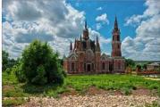
41. Downtown:

42. Spaso-Preobrazhensky Cathedral:

43. Preobrazhensky Park:


45. 500-meter pontoon crossing over the Yenisei. It is built every few years for planned exercises of the armed forces.